Gene Drive Explainer

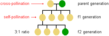
If you have even the foggiest memory of high school biology, you most likely, at some point, were acquainted with Gregor Mandel. He was an Austrian monk and naturalist who had a particular fondness for peas. Ring any bells? If not here’s a refresher: he found that when he crossed a purebred yellow pea plant with a purebred green pea plant, the offspring were all yellow. He then let those offspring self-fertilize and found that for every three yellow plants, there was one yellow one. From this little experiment, he deduced that some traits, like the “yellow” plant color in peas, are dominant over other traits like the “green” plant color. Moreover, he identified that each parent provided a factor (we now call them genes and call the set of their variants, alleles) that determined how the trait would appear in offspring, and that these factors are passed along independently of one another. Here’s a diagram to help make it more clear:

Source

Got it? Good. Well, I’m here to tell you that scientists have been working on technologies that tease and prod the rules of Mendelian inheritance and they’re doing it with a kind of technology called a gene drive. Gene drives bias the inheritance of certain alleles so that those alleles are driven throughout a population.

The idea of building a way to drive a specific gene throughout an entire population is not new, selfish genes, or genes that bias their own transmission, are found throughout nature.

In the 1960s, scientists imagined how we might take advantage of genetics to confer immunity to pathogens in insect pests. The idea of using genetics to manage wild populations gained more interest after Austin Burt in 2003 described the kind tool necessary to make it happen; a kind of “find and replace” for DNA.

In 2012, researchers finally had that tool — CRISPR. CRISPR, and its family of associated proteins (Cas), represent a big step up in how scientists find, cut, and replace genomic DNA. Its easier and more efficient to use than other techniques and is cheaper to boot. CRISPR is found in nature as a way for bacteria to defend themselves from viruses by maintaining short segments of viral DNA, as a sort of memory of infection, to use as a cutting pattern. Scientists can use this system to target and cut virtually any piece of DNA which can then be repaired to include virtually any other piece of DNA.

Source

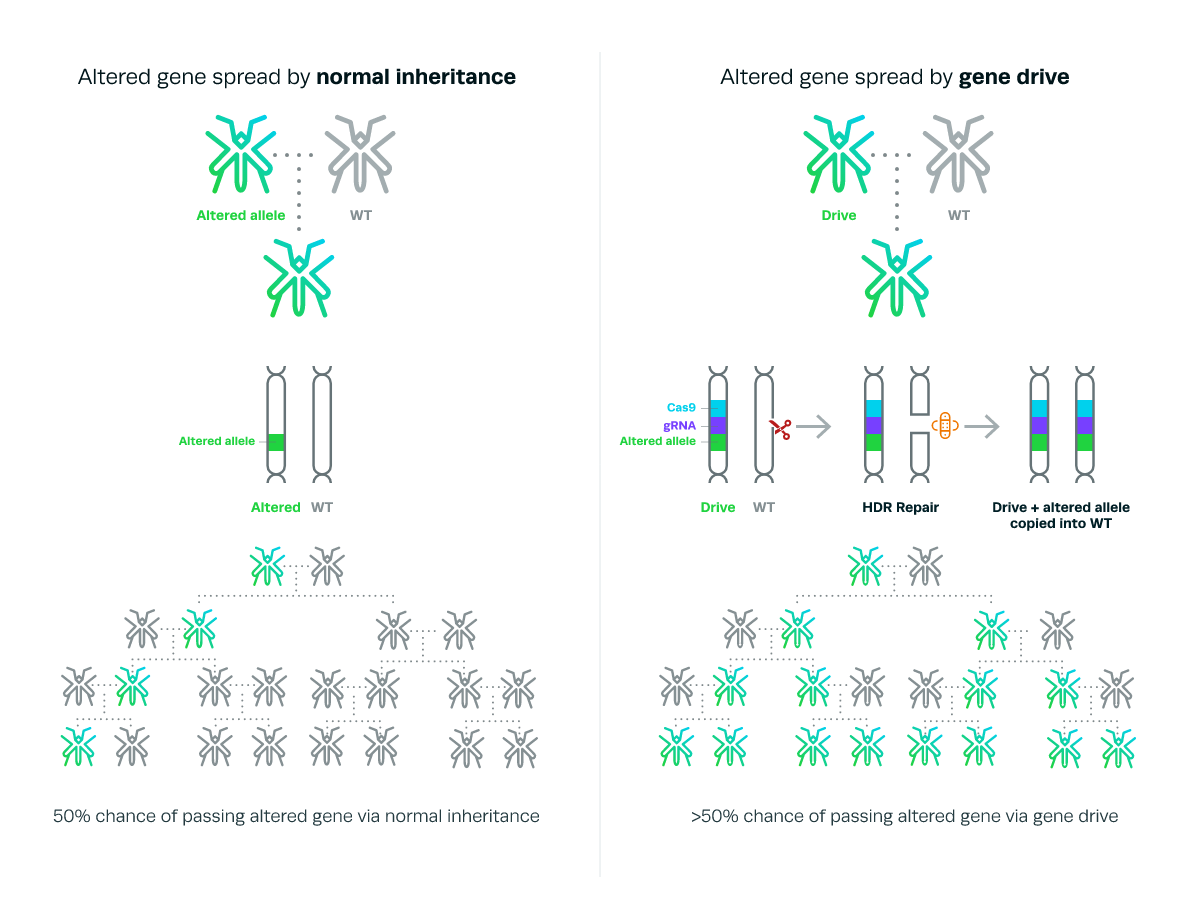
It’s important not to understate how remarkable it is to engineer a particular trait to be passed along hereditarily and this is true for two critical reasons. The first is that whenever we attempt to alter the genetics of an organism in the wild, the result is almost guaranteed to be less fit than its unaltered counterparts. This is because, fitness, or the ability to successfully compete and reproduce in the wild, is the lever by which natural selection works. The many forms of life we see around us are products of evolution, optimized for a given environment, and thus the winners of a competition that’s been happening since the dawn of life. The second is the biological process that passes on genes from each parent to the offspring happens on an incredibly short time scale. The entire process of finding, cutting and replacing genomic DNA has to be “turned on” at exactly the right time. Too early, and you might cause unintended effects that hurt fitness more, too late, and the window passes for the editing to be effectively inherited.

After reading that you might be wondering: how practical and/or feasible is it that gene drives will get made and released? Well, Gene drives could be very effective in slowing or eliminating the potential of vector-borne diseases spread by insects like Lyme, dengue, Zika, or malaria. As malaria alone is responsible for over 400,000 deaths a year and the mosquitos that are responsible serve no unique niche, there’s a strong incentive to develop the technology. In laboratory settings, scientists have been able to use a gene drive to crash a population of the malaria vector.  For species with long reproductive cycles, like humans, it would take an impractical amount of time, on the order of centuries or millennia. In agriculture, it may be useful to create localized drives to suppress the populations of pests like weeds. That being said, in the case of domesticated livestock, much of the reproductive cycle is already closely overseen by traditional methods and commercial-scale livestock already suffer greatly from a fitness disadvantage because of it.

Genome editing is still in its infancy — there is still much to discovered and discussed about how and when it used. Time will tell if gene drives will live up to the attention they have received.

Health and Wealth in Singapore

I approached this assignment with a data-first, narrative second perspective. I work on developing strategies for combating vector-borne diseases so the allied fields of epidemiology and geography seemed like a promising place to look for a story. One of the major vectors for diseases that affect humans (i.e. Zika, dengue fever, malaria, chikungunya) is the mosquito. There are several different kinds, but for the most part, they share a common taste in habitat. Places that are close to water, particularly stagnant freshwater, and get warm (as low as 60F, but ideally 70-80+ F) As I poked around the web trying to find workable datasets with this in mind, I came to find well-indexed mosquito and vector-borne disease maps from Singapore, provided by the government. I used Google MyMaps to create layers on this map that you can use to toggle between the overlays and I’ll walk you through some of the highlights.

One of the first things to know about Singapore, from an epidemiological perspective, is that it’s dense. There are over 5 million people living in an area under 300 square miles. Its the third most densely populated country in the world. While its very prosperous, it also faces a high level of income inequality — more unequal than the US and on par with Equador and Saudi Arabia (according to its Gini coefficient).

There were over 3000 cases of dengue reported in Singapore in 2018 an while the government maintains a high level of engagement in managing mosquito populations, the problem remains endemic. The National Environment Agency provides records of the location and number of reported dengue cases over a 14 day cycle, the last of which ended on November 7th, 2018.

This is a heat-map of the clusters of dengue fever in Singapore. The areas that are blue-green are clusters in the single digits and the double digits are in orange and yellow. We can see that cases not evenly distriubted throughout the country and most clusters are within a mile of another cluster.

Zooming in on the largest cluster, with 51 cases (just under half of the total of all sites), we can see that the areas of stagnant water (where mosquitos breed) were found exclusively in homes. Water collects in every-day, household-objects, as is does in public places and construction sites. It seems personal homes, perhaps due to lack of knowledge, are the entry point for the spread of the disease. This is a question we can explore further by looking at where the breeding sites for aedes aegypti were found in the graph

Overlaying the aedes aegypti breeding sites with the dengue clusters, something interesting pops up — the graphs don’t match. While there are breeding sites in areas that there are clusters, there are not clusters everywhere there are breeding sites. This is interesting because it indicates that there is something going on, education, norms, or otherwise, that is breaking the line of transmission in these areas. But, you could say, maybe what we see in the breeding overlay is actually a representation of all the areas where aedes aegypti mosquito breeds and not all mosquitos have the virus responsible. In which case, the next map to look at would be the overlay of the areas receptive to malaria

In the above map, the “natural” habitat suitable for the malaria vector (anopheles gambiae) serves as a proxy for “natural” habitat suitable for aedes egypti. This overlay shows that a large portion of the mosquito breeding sites are, in fact, outside of the malaria receptive areas. While this map can party be explained by a lack of sampling depth for breeding grounds in the receptive areas, the fact remains that areas that were not expected to be breeding grounds simply are. Life in the Anthropocene for the mosquito is booming.

Taking a step back and looking at the dengue clusters in relationship to the hotels, we can get a sense of the places that tourists are likely to be. This can serve as a proxy for areas that might be thought of as desirable. It surprised me to see that while there are some clusters close to hotel locations, the hotels seem to carefully avoid them. I was then interested to delve into looking at how sharp the economic divide might be at those borders. While I wasn’t able to find data that was easily transferable into the format of this map, below are two maps that can give some insight. The first is of the train-system throughout Singapore and the second is a property heat-map. I chose to look into the train system to see if there was a relationship between transport hubs and dengue clusters in terms of 1) disease mobility and 2) if economic centres (well-serviced by transit as a proxy) faced the same intensity of disease compared to less economically active areas. While perhaps useful, these might be questions that are beyond the scope of this assignment. The property heat-map can give some more understanding of where the affluent and economically disadvantaged live.

Bajaj, Abhishek. (2015). Exploring Urban Poverty in Singapore A lens on the influences acting on a child growing up in a lower socioeconomic environment. 10.13140/RG.2.1.4880.7767.

Turmeric Tension

I fact-checked a recipe from the popular wellness website Urban Remedy. Their current spokesperson/celebrity figurehead is Cindy Crawford. See my bounce annotations here.

Turmeric, which contains the chemical curcumin, has been the subject of a rather major theoretical flaw in the field of medicinal chemistry. See this opinion piece in Nature.

Reporting as Curation: Nebraska Flooding

This year has been one for the record books in Nebraska — at-least meteorologically . As the Omaha-World Herald reports, the period between September through February was the fifth-wettest fall-winter on record, this February the eighth-coldest on record. Thats not to mention that this recent deluge is responsible for Nebraska’s worst flooding in 50 years.

This flooding is due to a bomb cyclone, the meterological equivalent of a bass drop. When a low pressure system drops at-least 24 millibars in 24 hours, it undergoes the rather terrifyingly named explosive cyclogenesis. This pressure drop makes the ensuing storm stronger and can even approach a category 1 hurricane in terms of wind and rain.

As the waters recede, Its hard not to notice the how utterly un-drivable many of the roads underneath are. And it seems that this is not just the case of a single storm’s damage but indicative of a legacy of poor infrastructure management.

But it seems that this is part of a larger narrative of how poorly infrastructure has been managed in Nebraska recently. Take, for example, the snow storms of this past season:

In the heightened national attention, perhaps pressure to fix the roads will finally lead to serious investment. As it seems, the current government is slow to admit fault and responsibility.

Arab Spring Brings New Growth

BOSTON — The dust is still settling from the ongoing restructuring of the Middle East known as the Arab Spring. What started with the self-immolation of Tunisian street vendor Mohamed Bouazizi in 2011 has tapped a well of civil disobedience that has trickled throughout North Africa and the Middle East for nearly a decade.

In Egypt, the protests led to the ouster of then President Hosni Mubarak. His nearly thirty year rule came to an end after eighteen days of sustained demonstrations, both in the streets and online. In the upheaval since, Mubarak’s successor and Egypt’s first democratically elected president, Mohamed Morsi, was replaced after a term of just a year, in a coup d’état led by the military general Abdel Fattah el-Sisi.

While comprehensive death tolls have been difficult to tabulate; over eight-hundred civilians were killed and six-thousand injured in the eighteen days between the start of the protests and Mubarak’s ouster and conservative estimates place the death toll at over eight-hundred on just one day in 2013 during the Rabaa massacre by Egyptian security forces led by el-Sisi. The protestors, the people of Egypt at large, who have catalyzed the political upheaval in Egypt have also channelled their energies into alternative methods of civic engagement.

Amin Marei, a native Egyptian and a current Teaching Fellow at Harvard and the Associate Director for Professional Education for the Harvard Graduate School of Education, actively participated in the the Arab Spring by co-founding Mashroo3 Kheir (The Good Deed Project). I interviewed him to get his perspective on the Arab Spring, and what has happened since its first peak.

Wakanene Sebastian Kamau:   What motivated you to participate in the Arab Spring? What was your thought process behind starting Mashroo3 Kheir?

Amin Marei: For me, it was an opportunity to eradicate corruption in the country and to achieve social justice, freedom of expression and equity.The thought process behind Mashroo3 Kheir, which translates to (the Good Deed Project) was to capitalize on all the energy that was clearly present during the Arab Spring and try to channel it towards civic engagement and community development. The theory of action as, that if we provide the youth with opportunities to learn more about their communities and positively influence their society, then they can be actively engaged citizens who are able to tackle the challenges of their communities.  

WSK:  How would you describe the mission of Mashroo3 Kheir in your own words?A

M: To provide the youth with an opportunity to develop themselves while working with fellow citizens and learning from them.

WSK:  What were some of the successes/challenges in maintaining the growth of Mashroo3 Kheir?

AM: The successes include supporting the development of hundreds of volunteers who have been the part of Mashroo3 Kheir many of whom have become active members in their own communities. I hope that another success is supporting fellow members of the community in a thoughtful way. The challenges include navigating our way through complex laws and regulations. They also include working with volunteers, which has an element of unpredictability that makes it hard to sustain the work.  The other challenge is how to support other members within your community without being condescending or making them feel that you’re better than them. This is a real challenge in Egypt, and in the Middle East where classicism is a serious issue.

WSK: How involved are you in post-peak Arab spring activism?AM: I’m involved in projects that I would like to believe are related to activism, not necessarily in the traditional sense. Through my work at Harvard, I support the learning of phenomenal educators all over the Middle East. I also do my best to be as supportive as I can be to any person who is interested to support others within his/her community.

WSK: How involved you with activism in Egypt now that you are abroad?

AM: Again it depends on the definition, I’m definitely less involved since I’ve been living abroad for some time, but I do my best to stay connected and to support anyone who asks for my support.


4HR Story: Ansel Adams in the 21st Century

Does Ansel Adams need another retrospective? As perhaps our country’s most well-known landscape photographer, his expansive, cathedral-like depictions of the American West are as culturally ubiquitous as today as they have been in the thirty-five years since this passing. From the default desktop images on our computer operating systems to the stock photos on new picture frames, Ansel Adams, much like the mountains in his work, cast a long shadow.

Ansel Adams in Our Time, on display at the Museum of Fine Arts in Boston, takes on this implicit challenge by orienting the artist to be seen ‘through a contemporary lens.’ The show creates a visual bibliography of the artists work and situates it in the legacy of the government surveyors-photographers who came before him, and a range of contemporary photographers who have come after. At nearly 200-pieces, over 100 of which are his own, the exhibition has room to show the artist at his most iconic, “Clearing Winter Storm” and “Monolith, the Face of Half Dome”, while also including his lesser-known works from San Francisco.

The exhibition starts in a dim, verdant green gallery with prints arranged in no-frill rows. The orderly queue which forms as soon as one turns into the room, coupled with the low hum of bodies shuffling forward, create an atmosphere, not unlike a popular hike on a busy day. The most well-known prints are shown early and serve as cairns — they affirm the popular conception of Adams’ work and, when they peter out, signify that what lies beyond is outside the well-worn path. On the wall opposite the celebrity prints, contemporary artist Sharon Harper’s series of full-colour lichen-covered boulders serve as a counterbalance to the otherwise severe tone of the gallery. While the didactic texts adjoining Harper’s series explains that the style and inclusion of the lichen boulders are due to their treatment as “specimens in a 19th-century natural history museum”  the linkage feels tenuous and otherwise incongruous with the rest of gallery. This mismatch is an example of where the ambitious prospect of making Ansel Adams feel fresh, falls short.

To pick a guiding narrative for the show, the pieces exhibited underscore that ‘nature’ and its cousin ‘wilderness’ exist as concepts of our design; our politics and our aesthetics slant how we depict of them. This works best when different artists photograph the same site. This is done, by my count, twice, once with a juxtaposition of Adams with Carleton Watkins and once with Adams and English photographer Eadweard J. Muybridge. In both instances, Adams is shooting after the elder photographer and, in both instances, Adams’ version carefully removes signs of logging roads. To what end is Adams hoping to achieve with his edits? As a vocal political supporter of the parks, is his decision to show them as they could be instead of as they are to be read as a wishful thinking or a way to inspire others to value them? Or does he just think they look better without the signs of human influence?

Furthermore, What does this all say about the American West today? While we have more parks (there are now 61 national parks in the United States) we are still negotiating land rights, regularly deal with drought, and continue to exploit natural resources. From the lens of the collection of contemporary artists saved for the final room, the time for aesthetic retouchings of the West is over. The political, economic, and environmental stakes are too are simply too high to be ignored. Stephen Tourlentes captures the eerie light from a remote Colorado Super Max prison at night, a reminder that mass incarceration is perhaps an even more insidious issue when it is intentionally placed out-of-sight. The harsh fiscal and environmental realities of the desert are  portrayed by Bryan Schumaat using a modern ghost town-turned-dump and Victoria Sambunaris’ rich birds-eye view of Wendover, Utah, a city on the edge of the desert and mountain range. Mitch Epstein’s ‘Altamont Pass Wind Farm, California’ points out the absurdity of the underlying motivations in our society that cause us to develop and maintain a golf course in the desert, next to a wind farm. These photographs are deeply emotional, their resonance to our day and age should have warranted greater emphasis in the exhibit. Ansel Adams captured the zeitgeist of the West during his time. While he doesn’t map cleanly to ours, the broad themes run current today.